01
Millimeter precision
World leader in high-precision measurement technologies.
Leica Geosystems instruments for 3D laser surveying and measurement of the highest precision: BLK360 for the point cloud, robotic iCON, dedicated software for professional scans.
Leica Geosystems is a leader in supplying state-of-the-art laser surveying and measurement instruments, with extremely high precision in the detection of measurements. Leica solutions allow entire environments to be surveyed easily and quickly, with modern software for processing 3D scans. Standouts are the BLK360 for the point cloud and the robotic iCON: compact products for navigable 3D measurements, usable for anchor points, height transfers and BIM checks.

Robotic site station with laser technology and the wireless Leica vPen. High performance even on reflective or glossy surfaces, for outstanding flexibility and efficiency in layout.
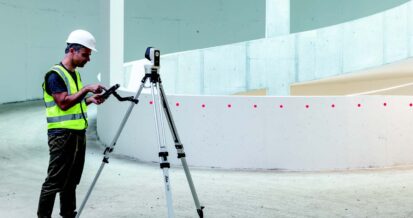
Motorized site station with high-resolution cameras for precise aiming. 2D and 3D data capture, automatic setup and single-operator use.
World leader in high-precision measurement technologies.
Compact, intuitive instruments, usable on site by a single operator.
Direct output to the main BIM and CAD software in the industry.